C-UAS System
Counter-Unmanned Aircraft System · Product Portfolio & Specifications
Systems in This Portfolio
(1) Passive Air Defense EO System
Passive EO search & tracking, zero emission
(2) 5 km X-band Radar (NOR-04B)
Phased-array detection, ≥5 km on 0.01 m² RCS
(3) Radio Interference System
300 MHz – 6 GHz jamming, ≥3 km
(4) 5 kW Laser UAV Countermeasure System
Hard-kill laser, destroy in <4 s at 800 m
(5) Intelligent Command and Control Platform
Up to 128 radars, 20,000 km² coverage
(1) Passive Air Defense EO System
Product Overview

The EO system combines search and tracking in one fully passive electro-optical system. Emitting no electromagnetic waves, it searches, tracks and identifies targets while the radar stays silent — one 360° azimuth × 18° elevation scan per second, with 7×24h automatic alerting and real-time multi-target trajectory monitoring.
Key Features
-
Passive by design — zero electromagnetic emission; operates under full radar silence.
-
One-second full coverage — 360° × 18° scanned every second; ≥50 targets handled simultaneously.
-
Long reach, sharp detail — ultra-long-focus optics detect at 35 km and identify at 25 km.
-
AI-powered and unattended — intelligent recognition drives automatic detection and early warning.
-
Open integration — standard network interfaces link to air-situation networks and EFF secondary radar.
Applications
Key-area counter-UAV · Accompanying air defense · High-value asset protection
Technical Specifications
Item
Specification
Search Airspace
360° × 18°
Search Speed
60 rpm
Target Capacity
≥ 50 batches
Thermal Imager
MWIR, 1280×1024, 40–750 mm, 50 Hz
Visible Camera
1920×1080, 20–1200 mm, 50 Hz
Laser Rangefinder
80 m – 40 km, ±3 m
Turret
Azimuth n×360°; Elevation −10° to +70°; 0.3 mrad
Interface
Ethernet; DC 18–36 V
(2) 5 km X-band Radar (NOR-04B)
Technical Specifications
Item
Specification
Radar Band
X-band
Detection Distance
≥ 5 km (RCS = 0.01 m²)
Min. Detectable Velocity
1 m/s
Min. Detectable Range
≤ 150 m
Detection Angle Coverage
Azimuth 360°; Pitch 0°–50°
Airspace Coverage Height
≥ 500 m (RCS = 0.01 m²)
Target Capacity
TWS ≥ 500 pieces; TAS ≥ 16 pieces
Accuracy (RMS)
Distance ≤ 8 m; Azimuth ≤ 0.5°; Pitch ≤ 0.5°
Scan Cycle
≤ 3 s (TWS); ≤ 0.5 s (TAS)
Communication Protocol
UDP
Power Supply
48 V
Average Power Consumption
≤ 1600 W
Relative Humidity
95 ± 3% @ 30 °C
Storage Temperature
−50 °C to +85 °C
Working Temperature
−40 °C to +70 °C
Protection Grade
IP65
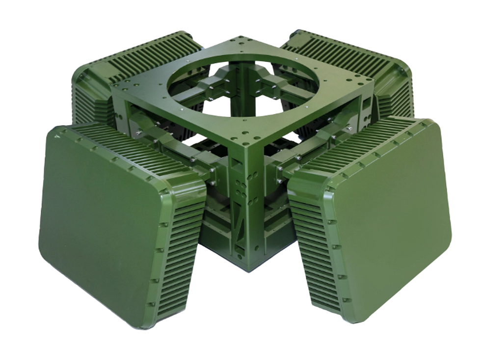
The NOR-04B is a two-dimensional phased-array, three-coordinate radar. It detects and tracks low-altitude drones, helicopters and other targets, measuring target azimuth, elevation, distance and speed, and reports radar status and target information to the command and control center through the network port.
(3) Radio Interference System
The radio interference system suppresses UAV control and navigation links across a wide frequency band, with arbitrary output setting per interference channel and omni-directional beam coverage for rapid response.
Technical Specifications
Item
Specification
Interference Frequency Range
300 MHz – 6 GHz; interference channel output can be set arbitrarily
Interference Distance
≥ 3 km (0.1 W radiation source)
Jamming-to-Signal Ratio
Not less than 10:1
Interference Beam Range
Horizontal 360°; elevation ≥ 70°
Interference Effective Time
≤ 3 s

(4) 5 kW Laser UAV Countermeasure System

The system tightly integrates high-performance visible / infrared multi-band detectors, a high-precision tracking turntable, a high-power laser, power supply and thermal management modules. With the latest image processing and composite-axis control technology, it captures, tracks and attacks targets effectively. It can be installed on rooftops or vehicles and operates unattended 24 hours a day.

Technical Specifications
Item
Specification
UAV Detection Range
> 2000 m
UAV Tracking Distance
500 – 1500 m
Lethal Distance
500 – 1000 m
Time to Destroy
< 4 s @ 800 m
Target Dimensions
0.3 m × 0.3 m
Laser Effector
5 kW
Rotating Range
Orientation 160°; Pitch −10° to +70°
Dimensions
460 mm (W) × 1100 mm (L) × 900 mm (H)
Weight
< 200 kg with 8 kWh battery
Power Supply
Built-in high-power lithium-ion battery; charging input AC 220 V
Power Consumption
Average ≤ 7 kW
Operating Temperature
−10 °C to +70 °C (with cooling system)
(5) Intelligent Command and Control Platform
The Intelligent Command and Control Platform is the core of the distributed anti-UAV defence system, underpinned by a highly secure encrypted data link for real-time, tamper-resistant communication and seamless interconnection of all field devices.
It centrally orchestrates up to 128 radar units and 256 interceptor drone bases (6 interceptor drones per base max), laser countermeasure systems or other networked equipment, forming a protected anti-UAV airspace of up to 20,000 km².

Product Features
-
In unattended mode, the system automatically receives UAV data, activates confirmations, or directs jamming equipment.
Unattended Operation
-
Displays model, frequency, position, speed and trajectory on the GIS map.
Target Information Display
-
Allows configuration of protection zones including core area, disposal area and alarm area.
-
Supports drawing polygonal or circular protection zones.
Protection Zone Setting
Trajectory Display
-
Displays plots and / or trajectories of UAV targets.
-
Supports multi-target tracking; when multiple UAVs are detected simultaneously, the flight path of each is displayed separately.
Countermeasure Equipment Control
-
Supports countermeasure modes: anti-UAV drone, laser countermeasure, forced landing, etc.
-
Supports jamming modes: manual, semi-automatic and unattended.
Blacklist & Whitelist Management
-
Allows adding or removing whitelisted UAVs.
-
Differentiates whitelisted and non-whitelisted UAVs with distinct colours, icons and text labels.
-
Provides data recording, storage and playback functions.
-
Records and stores UAV target model, detection time, departure time, flight trajectory, detection equipment and other information.